Bird strikes pose a severe threat to military aircraft. Although fatal accidents are rare, bird strikes can cause considerable damage to aircraft, which can be expensive and debilitating – keeping aircraft grounded and dysfunctional.
Most bird activity happens in lower airspace, so bird strikes are most likely to occur during take-off, initial climb, and landing. Military aircraft are at an increased risk than civil aircraft, as military training and operations often occupy the lower airspace around the airbase.
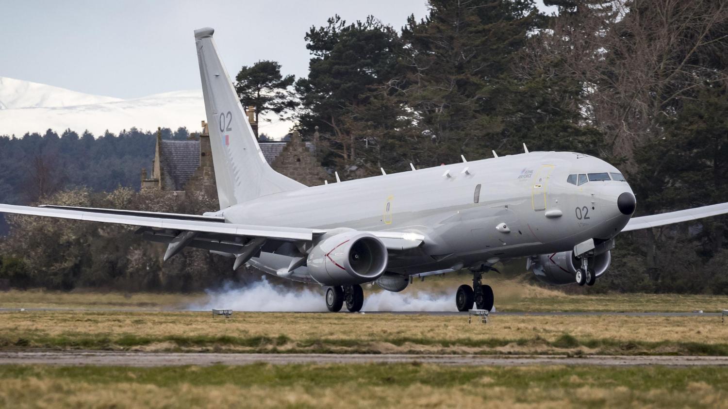
The decision to base the Poseidon at RAF Lossiemouth required a review of the bird strike risk due to the increased risk-to-life (RtL) of a multi-crew platform operating from an airfield with a high local bird population. Work had previously been ongoing for the provision of a Bird Detection System (BDS) at Lossiemouth since the arrival of Typhoon but had not secured funding.
Following the submission of a Duty Holder Advice note to AOC 1Gp on the P-8A Birdstrike RtL, the direction to run a trial of a BDS at Lossiemouth was given. The Rapid Capabilities Office (RCO), Robin Radar Systems and RAF Lossiemouth had less than six months to find & deliver a solution, and Trial WINCHELL was initiated.
This project required the RCO, the Lossiemouth Team and Robin Radar Systems to identify a suitable system for the trial; identify a suitable site for the radar; deliver the infra and utilities to the approved bare bones site; obtain frequency clearance to operate the radar, and have the radar delivered and installed from the Netherlands within six months.
This was to be completed during the COVID-19 pandemic and with Lossiemouth mid-way through a huge runway resurfacing programme.
The mission outcome? Success.
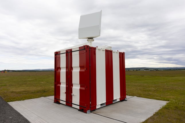
After some excellent work by the RCO, Robin Radar Systems and Lossiemouth, a MAX advanced BDS was installed and operational to support the start of P-8A operations in November 2020.
After completing the successful 18-month 'proof of concept' trial period, Robin Radar Systems was awarded a 5-year contract for the provision of a BDS at RAF Lossiemouth.
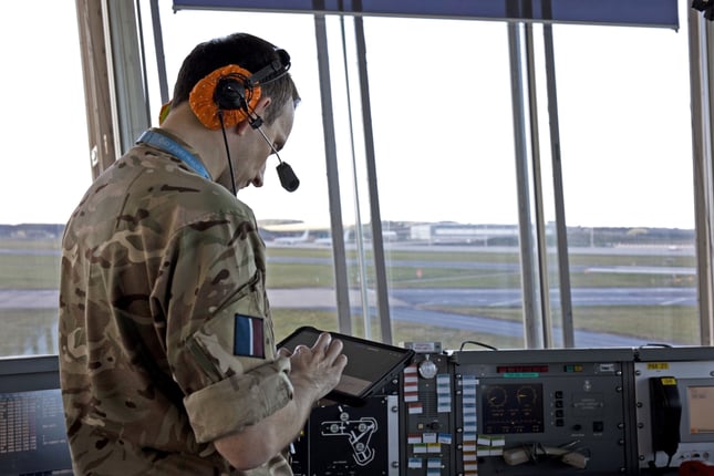
Over the past two years, the radar system has continually gathered 24/7 relevant data about bird movements over and near the airfield, assisting in planning and managing the risks posed by birds to flight operations
The radar can detect and log hundreds of birds at once, including their size, speed, direction, and flight path, which makes it the ideal solution for a large site spanning a wide area like Lossie. The technology can also be integrated with other systems to trigger warnings or preventative action.
The radar detects bird activity day and night and can continuously measure the number of birds entering a particular airfield area. It can also initiate alerts before threats become visible or when birds cross a designated threshold. Before an alert is triggered, many factors are considered, including wind direction, bird behaviour, time of day, and the season.
Speaking on Lossiemouth’s particular vulnerability to bird hazards, a Squadron Leader from the station said:
Lossiemouth has a unique bird strike risk due to being a coastal airfield surrounded by farmland containing a large number of pig farms. There are high numbers of corvids and seagulls in the vicinity of the RAF base, and every winter, around 10,000 geese arrive in Findhorn Bay. This high level of activity, combined with the statistic that around 80% of bird strikes in the UK happen at, or in the vicinity of, airports highlights the value of having an in-depth understanding of the avian picture.
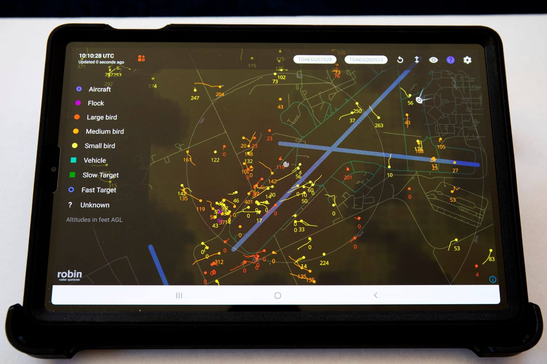
Before the introduction of the MAX, Lossiemouth minimised flying activity during peak bird activity to mitigate the bird strike risk. This restriction impacted planning and reduced operational flexibility, especially for the P-8A due to its sortie profiles.
The BDS provides real-time height and positional information of airborne targets in 360° and can accurately track avian activity as far as 10km. Over the past two years, confidence in the BDS performance has facilitated the development of effective operational procedures.
The data provided by the BDS has also enabled Lossiemouth to reduce the level of restriction on operations during peak bird times, which has increased the flying window.
A Squadron Leader and member of the Poseidon crew at the station said:
I was extremely impressed with how accurate it was. It seemed to accurately depict, not only the number and size of the birds, but the height, location and direction of travel.
The findings from the trial will also provide valuable future research for other RAF stations, tackling the threat of bird strikes in a more strategic way to reduce the danger and impact of bird strikes at military air bases.
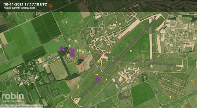
Example of the BDS in action at Lossiemouth
On 10 November 2021, RAF Lossiemouth’s new BDS capabilities were demonstrated to good effect.
At 17:11, while an RAF P-8 was inbound for an ILS approach, MAX detected potentially hazardous bird activity over runway 23.
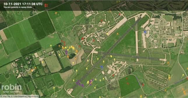
17:11 P-8 inbound for an ILS approach. Radar detects a high bird return over the 05 cable, with the flock tracking SE-NW at an altitude of 1100ft on 1013hPa. Air system breaks off at 4.5 miles.
17:17 A second return shows high bird activity further up the cable and crossing the runway from SSE-NNW. Approximate height 600 - 1000ft.
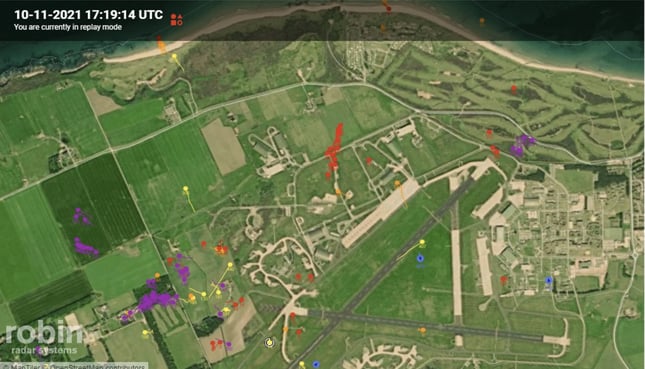
17:19 Radar detects another large return just off the runway 23 threshold tracking E-W at approximately 600ft. P-8 at downwind leg of RTC
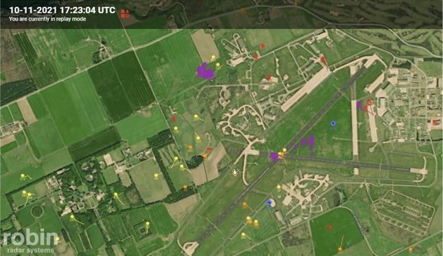
17:23 Radar detects two large flocks over the intersection and north side of runway 23, tracking E-W and S-N between 550- 1000ft. P-8 within 4 miles of the runway and awaiting clearance. The supervisor instructs the controller to break off the approach.
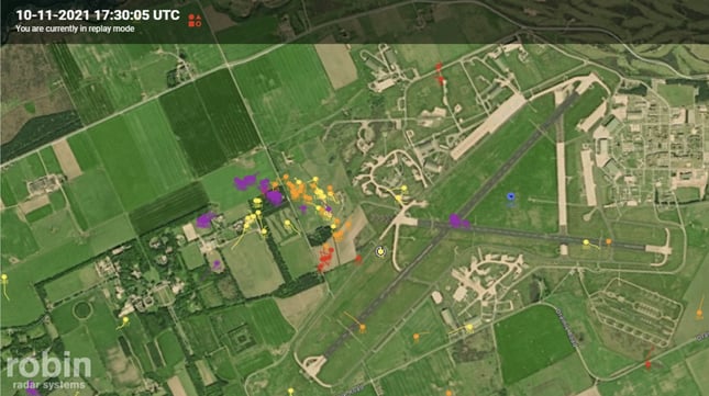
17:30 Another flock is detected over the intersection. However, this one is stationary at an altitude of 300-800ft. This causes the contacts to merge and makes height visibility unclear. P-8 downwind of the RTC for a further ILS to land.
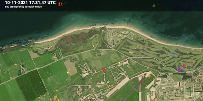
17:31 P-8 on final approach and awaiting clearance to land. The radar shows no large bird returns on or above the runway. One flock, tracking NE-SW, turns directly W after the aircraft has passed. P-8 lands safely.
Radar to the Rescue
Thanks to the real-time data provided by the BDS to the Bird Control Unit and the ATC Supervisor using the tablet displays, the ATC supervisor was given an advanced warning of potentially hazardous bird activity around runway 23. This enabled both the Bird Control Unit and the ATC Supervisor to monitor and track nearby flocks accurately, aiding recovery and reducing the bird strike risk. Due to night-time conditions, it was unclear whether the human eye could have replicated the radar returns.
In this instance, the approaching Poseidon got an advanced warning of bird location and activity. During high bird activity, these flocks were monitored and tracked by the BDS, assisting with the recovery. Without the available data, the Poseidon would likely have continued to land on first approach, without knowing the potential severity of the bird flock ahead of it. This scenario is an excellent example of how the use of the BDS capability can reduce the Lossiemouth bird strike risk.
RAF Lossiemouth’s Bird Control Unit Wildlife Manager:
“Airfield Wildlife Control Operators are active on the airfield during all flying hours to detect and disperse any bird activity. Since the radar has come into force, they have access to an in-vehicle tablet, which allows them to track the birds' movements detected by the radar in real-time and pass on any potentially dangerous bird activity to the controllers in the tower to communicate with the pilots.
The radar has especially proven its benefit during periods of darkness, where the wildlife operators previously had limited visibility and had to rely more on their auditory sense; now, they have a visual aid in the radar. In addition, the radar outputs all data collected, including but not limited to the number of near-misses, birds crossing the runway and exact bird hot spot areas. The Wildlife Hazard Management Unit can now access and analyse this information to better understand and predict local bird patterns and trends.”
RAF Lossiemouth’s Trial WINCHELL and BDS Project Lead:
“The success of Trial WINCHELL has resulted in the provision of highly capable BDS at LOS, with LOS currently being the only airfield in the UK with this capability. During and post-Trial WINCHELL, the BDS has proven to be effective in helping to reduce the bird strike risk at LOS, enabling the Bird Control Unit to provide both visual and digitally acquired information to ATC on potentially hazardous bird activity.
This capability comes into its own during the winter months as we are now able to detect and track skeins of geese flying over, or near the airfield, during darkness, reducing the risk to both the Poseidon and Typhoon and, in the future, the E7. The RCO and Robin Radar Systems were pivotal in helping to deliver the capability in such a demanding timeframe. Numerous issues were overcome through effective collaborative working and the can-do approach of the RCO, Robin Radar and the LOS Team. Robin Radar has also recently upgraded the radar with a new module to detect and track drones and we are looking forward to exploiting this additional capability."
This article originally appeared in the RAF Total Safety Magazine, Air Clues, Issue 39, October 2022:
Don’t Leave Your Business Vulnerable
Find out how our radars can make your operations safer with actionable data. Get in touch today.

